
ⴰⴼⴰⵢⵍⵓ:World ocean map-fr.gif
ⵓⵔ ⵜⵍⵍⵉ ⵜⵙⴷⴷⵉ ⵉⵎⵇⵇⵓⵔⵏ ⵓⴳⴳⴰⵔ
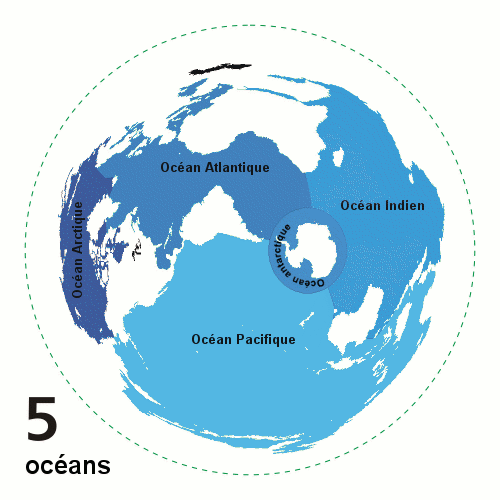
World_ocean_map-fr.gif (500 × 500 ⵉⴷ ⴱⵉⴽⵙⵍ, ⵜⵉⴷⴷⵉ ⵏ ⵓⴼⴰⵢⵍⵓ: 108 KB, ⴰⵏⴰⵡ MIME: image/gif, looped, 4 frames, 10 s)
| ⴰⴳⵍⴰⵎ |
English: Animated world ocean map (GIF), exhibiting various oceans.
Azimuthal distance projection map is based on world map from this online Java tool by Henry Bottomley and altered using CorelDraw/PhotoPaint, et al. Map is centered on 85° W, 45° S, rotated 90° CCW (North Pole is to the left). Ocean boundaries per International Hydrographic Organisation.
|
||
| ⴰⵙⴰⴽⵓⴷ | |||
| ⴰⵙⴰⴳⵎ | Own work, french translation of Image:World ocean map.gif created by User:Quizatz Haderach, based on Image:Oceans.png and animated design inspired by Image:Continental models.gif. | ||
| ⴰⵎⴳⴰⵢ | Emmanuel.boutet | ||
| ⵜⵓⵔⴰⴳⵜ (ⵙⵙⵎⵔⵙ ⴷⴰⵖ ⴰⴼⴰⵢⵍⵓ ⴰ) |
|
||
| Other versions |
 |
ⴰⵎⵣⵔⵓⵢ ⵏ ⵓⴼⴰⵢⵍⵓ
ⴽⵍⵉⴽⵉ ⵖⴼ ⵓⵙⴰⴽⵓⴷ/ⴰⴽⵓⴷ ⵃⵎⴰ ⴰⴷ ⵜⵙⴽⵏⴷ ⴰⴼⴰⵢⵍⵓ ⵎⴰⵏⵎⴽ ⴰⴷ ⵢⴰⴷⵍⵍⵉ ⵉⴳⴰ ⴳ ⵡⴰⴽⵓⴷ ⴰⵏⵏ.
| ⴰⵙⴰⴽⵓⴷ/ⴰⴽⵓⴷ | ⵜⴰⵡⵍⴰⴼⵜ ⵎⵥⵥⵉⵢⵏ | ⵉⵎⵏⴰⴷⵏ | ⴰⵏⵙⵙⵎⵔⵙ | ⴰⵖⴼⴰⵡⴰⵍ | |
|---|---|---|---|---|---|
| ⴰⵎⵉⵔⴰⵏ | 11:23, 8 ⴽⵟⵓⴱⵕ 2007 | | 500 × 500 (108 KB) | Emmanuel.boutet | |
| 09:50, 8 ⴽⵟⵓⴱⵕ 2007 |  | 500 × 500 (108 KB) | Emmanuel.boutet | {{Information |Description= {{en|Animated world ocean map (GIF), exhibiting various oceans. Created by User:Quizatz Haderach, based on Image:Oceans.png and animated design inspired by Image:Continental models.gif. Azimuthal distance projec |
ⴰⵙⵎⵔⵙ ⵏ ⵓⴼⴰⵢⵍⵓ
ⵜⴰⵙⵏⴰ ⴰⴷ ⵜⵙⵎⵔⵙ ⴰⴼⴰⵢⵍⵓ ⴰⴷ:
ⴰⵙⵎⵔⵙ ⴰⵖⵣⵓⵔⴰⵏ ⵏ ⵓⴼⴰⵢⵍⵓ
ⵉⵡⵉⴽⵉⵜⵏ ⴰⴷ ⵢⴰⴹⵏⵉⵏ ⴰⵔ ⵙⵙⵎⵔⵙⵏ ⴰⴼⴰⵢⵍⵓ ⴰⴷ:
- ⴰⵙⵎⵔⵙ ⴳ fr.wikipedia.org
- ⴰⵙⵎⵔⵙ ⴳ gcr.wikipedia.org
- ⴰⵙⵎⵔⵙ ⴳ hu.wikipedia.org
- ⴰⵙⵎⵔⵙ ⴳ incubator.wikimedia.org
- ⴰⵙⵎⵔⵙ ⴳ nap.wikipedia.org
- ⴰⵙⵎⵔⵙ ⴳ vec.wikipedia.org