
ⴰⴼⴰⵢⵍⵓ:Nile watershed topo.png
ⵜⵉⴷⴷⵉ ⵏ ⵜⵎⵓⵖⵍⵉ ⴰⴷ: 285 × 599 ⵉⴷ ⴱⵉⴽⵙⵍ. ⵜⵉⴼⵙⴰⵢⵉⵏ: ⵢⴰⴹⵏ 114 × 240 ⵉⴷ ⴱⵉⴽⵙⵍ | 554 × 1 164 ⵉⴷ ⴱⵉⴽⵙⵍ.
ⴰⴼⴰⵢⵍⵓ ⴰⵙⴰⵍⴰⵏ (554 × 1 164 ⵉⴷ ⴱⵉⴽⵙⵍ, ⵜⵉⴷⴷⵉ ⵏ ⵓⴼⴰⵢⵍⵓ: 560 KB, ⴰⵏⴰⵡ MIME: image/png)
ⴰⵙⴳⵣⵍ
| ⴰⴳⵍⴰⵎ |
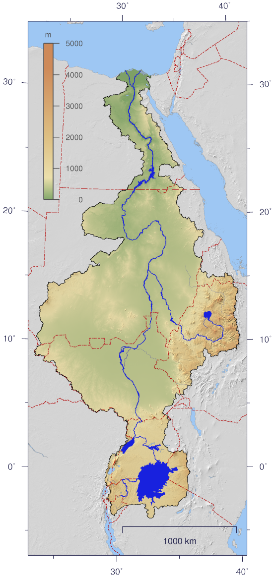
English: Course and Watershed of the Nile with topography shading and political boundaries.
Deutsch: Verlauf und Einzugsgebiet des Nils mit Reliefschattierung und Staatsgrenzen.
العربية: مجرى نهر النيل و الأراضي التي تروى بماءه مع طوبوغرافيا الأرض المحيطة به و الحدود السياسية |
| ⴰⵙⴰⴽⵓⴷ | |
| ⴰⵙⴰⴳⵎ | The map has been created with the Generic Mapping Tools: http://gmt.soest.hawaii.edu/ using additional public domain data from the VMAP0 and HYDRO1K data sets. The map is in Transverse Mercator projection with central meridian at 32.5° east. |
| ⴰⵎⴳⴰⵢ | Imagico |
| ⵜⵓⵔⴰⴳⵜ (ⵙⵙⵎⵔⵙ ⴷⴰⵖ ⴰⴼⴰⵢⵍⵓ ⴰ) |
This file is licensed under the Creative Commons Attribution-Share Alike 2.5 Generic license.
|
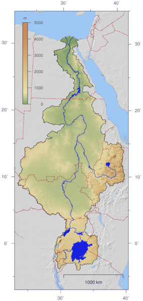
| Other versions | Image:Nile_watershed_plain.png |
ⵜⵓⵔⴰⴳⵜ
I, the copyright holder of this work, hereby publish it under the following license:
This file is licensed under the Creative Commons Attribution-Share Alike 2.5 Generic license.
- ⵜⴳⵉⴷ ⵉⵍⴻⵍⵍⵉ:
- ⴱⴹⵓ – ⵉ ⵓⵙⵙⵏⵖⵍ, ⴰⴱⵟⵟⵓ ⴷ ⵓⵙⵎⵓⵜⵜⵢ ⵏ ⵜⵡⵓⵔⵉ
- ⵛⵛⴰⵔ – ⵉ ⵓⵙⵎⵙⴰⵙⴰ ⵏ ⵜⵡⵓⵔⵉ
- ⴷⴷⴰⵡ ⵜⴼⴰⴷⵉⵡⵉⵏ ⴰⴷ:
- ⴰⵎⴰⵙ – ⵉⵇⵇⴰⵏ ⴷ ⴰⴷ ⵜⴼⴽⴷ ⵓⵎⵍⴰⵏ ⵖⴼ ⵓⵎⴳⴰⵢ, ⵜⴼⴽⴷ ⴰⵙⵖⵏ ⵖⵔ ⵜⵓⵔⴰⴳⵜ, ⵜⵎⵍⴷ ⵉⵖ ⵉⵜⵜⵡⴰⵙⵏⴼⵍ. ⵜⵣⴹⴰⵔⴷ ⴰⴷ ⵜⵙⴽⵔⴷ ⵎⴽ ⴰⴷ ⵙ ⵜⵖⴰⵔⴰⵙⵜ ⵏⵏⴰ ⴷ ⵢⵓⵙⴰⵏ, ⵎⴰⵛ ⵓⵔ ⴷ ⴽⵔⴰ ⵏ ⵜⵖⴰⵔⴰⵙⵜ ⵉⵎⵎⴰⵍⵏ ⵎⴰ ⵙ ⴷ ⴰⵎⴳⴰⵢ ⴰⵔ ⴽ ⵉⵏⵏⴰⵍ ⵏⵖ ⴷ ⴰⵙⵎⵔⵙ ⵏⴽ.
- ⴱⴹⵓⵜ ⵎⴽⵍⵍⵉⵜ – ⵎⴽ ⵜⵙⵏⴼⵍⴷ ⵏⵖ ⵜⵙⵎⵓⵜⵜⵉⴷ ⵏⵖ ⵜⵥⴽⵉⴷ ⵖⴼ ⵜⵡⵓⵔⵉ, ⵉⵇⵇⴰⵏⴽ ⵉⴷ ⴰⴷ ⵜⴱⴹⵓⴷ ⵜⵓⵎⵓⵜⵉⵏ ⵏⴽ ⴷⴷⴰⵡ ⵜⵓⵔⴰⵇⵜ ⴰⵏⵏ ⵏⵉⵜ ⵏⵖ ⴽⵔⴰ ⵏ ⵜⵓⵔⴰⴳⵜ ⴷ ⵢⵓⵙⴰⵏ ⴷ ⵜⴷⵙⵍⴰⵏⵜ.
ⴰⵎⵣⵔⵓⵢ ⵏ ⵓⴼⴰⵢⵍⵓ
ⴽⵍⵉⴽⵉ ⵖⴼ ⵓⵙⴰⴽⵓⴷ/ⴰⴽⵓⴷ ⵃⵎⴰ ⴰⴷ ⵜⵙⴽⵏⴷ ⴰⴼⴰⵢⵍⵓ ⵎⴰⵏⵎⴽ ⴰⴷ ⵢⴰⴷⵍⵍⵉ ⵉⴳⴰ ⴳ ⵡⴰⴽⵓⴷ ⴰⵏⵏ.
| ⴰⵙⴰⴽⵓⴷ/ⴰⴽⵓⴷ | ⵜⴰⵡⵍⴰⴼⵜ ⵎⵥⵥⵉⵢⵏ | ⵉⵎⵏⴰⴷⵏ | ⴰⵏⵙⵙⵎⵔⵙ | ⴰⵖⴼⴰⵡⴰⵍ | |
|---|---|---|---|---|---|
| ⴰⵎⵉⵔⴰⵏ | 22:06, 25 ⵖⵓⵛⵜ 2016 | | 554 × 1 164 (560 KB) | Janitoalevic | Updated borders. |
| 14:59, 4 ⵉⵏⵏⴰⵢⵔ 2007 |  | 554 × 1 164 (527 KB) | Imagico | {{Information |Description= {{en|Course and Watershed of the Nile with topography shading and political boundaries.}} {{de|Verlauf und Einzugsgebiet des Nils mit Reliefschattierung und Staatsgrenzen.}} |Source=The map has been created with the [[:en:Gener |
ⴰⵙⵎⵔⵙ ⵏ ⵓⴼⴰⵢⵍⵓ
ⵜⴰⵙⵏⴰ ⴰⴷ ⵜⵙⵎⵔⵙ ⴰⴼⴰⵢⵍⵓ ⴰⴷ:
ⴰⵙⵎⵔⵙ ⴰⵖⵣⵓⵔⴰⵏ ⵏ ⵓⴼⴰⵢⵍⵓ
ⵉⵡⵉⴽⵉⵜⵏ ⴰⴷ ⵢⴰⴹⵏⵉⵏ ⴰⵔ ⵙⵙⵎⵔⵙⵏ ⴰⴼⴰⵢⵍⵓ ⴰⴷ:
- ⴰⵙⵎⵔⵙ ⴳ af.wikipedia.org
- ⴰⵙⵎⵔⵙ ⴳ ar.wikipedia.org
- ⴰⵙⵎⵔⵙ ⴳ as.wikipedia.org
- ⴰⵙⵎⵔⵙ ⴳ ca.wikipedia.org
- ⴰⵙⵎⵔⵙ ⴳ cdo.wikipedia.org
- ⴰⵙⵎⵔⵙ ⴳ ckb.wikipedia.org
- ⴰⵙⵎⵔⵙ ⴳ crh.wikipedia.org
- ⴰⵙⵎⵔⵙ ⴳ da.wikipedia.org
- ⴰⵙⵎⵔⵙ ⴳ en.wikipedia.org
- ⴰⵙⵎⵔⵙ ⴳ es.wikipedia.org
- ⴰⵙⵎⵔⵙ ⴳ fa.wikipedia.org
- ⴰⵙⵎⵔⵙ ⴳ fr.wikipedia.org
- ⴰⵙⵎⵔⵙ ⴳ fy.wikipedia.org
- ⴰⵙⵎⵔⵙ ⴳ hy.wikipedia.org
- ⴰⵙⵎⵔⵙ ⴳ hyw.wikipedia.org
- ⴰⵙⵎⵔⵙ ⴳ incubator.wikimedia.org
- ⴰⵙⵎⵔⵙ ⴳ ja.wikipedia.org
- ⴰⵙⵎⵔⵙ ⴳ ja.wikibooks.org
- ⴰⵙⵎⵔⵙ ⴳ jbo.wikipedia.org
- ⴰⵙⵎⵔⵙ ⴳ kbd.wikipedia.org
- ⴰⵙⵎⵔⵙ ⴳ lez.wikipedia.org
- ⴰⵙⵎⵔⵙ ⴳ lv.wikipedia.org
- ⴰⵙⵎⵔⵙ ⴳ new.wikipedia.org
- ⴰⵙⵎⵔⵙ ⴳ nl.wikipedia.org
- ⴰⵙⵎⵔⵙ ⴳ nn.wikipedia.org
- ⴰⵙⵎⵔⵙ ⴳ no.wikipedia.org
- ⴰⵙⵎⵔⵙ ⴳ nso.wikipedia.org
- ⴰⵙⵎⵔⵙ ⴳ pa.wikipedia.org
- ⴰⵙⵎⵔⵙ ⴳ pms.wikipedia.org
- ⴰⵙⵎⵔⵙ ⴳ roa-rup.wikipedia.org
- ⴰⵙⵎⵔⵙ ⴳ ru.wikipedia.org
- ⴰⵙⵎⵔⵙ ⴳ sco.wikipedia.org
- ⴰⵙⵎⵔⵙ ⴳ si.wikipedia.org
ⵙⴽⵏ ⵓⴳⴳⴰⵔ ⵖⴼ ⵓⵙⵙⵎⵔⵙ ⴰⵎⴰⵜⴰⵢ ⵏ ⵓⴼⴰⵢⵍⵓ ⴰⴷ.