ⴰⴼⴰⵢⵍⵓ:Nasa world wind - teneriffa.jpg

ⵜⵉⴷⴷⵉ ⵏ ⵜⵎⵓⵖⵍⵉ ⴰⴷ: 800 × 599 ⵉⴷ ⴱⵉⴽⵙⵍ. ⵜⵉⴼⵙⴰⵢⵉⵏ: ⵢⴰⴹⵏ 320 × 240 ⵉⴷ ⴱⵉⴽⵙⵍ | 640 × 479 ⵉⴷ ⴱⵉⴽⵙⵍ | 1 024 × 766 ⵉⴷ ⴱⵉⴽⵙⵍ | 1 280 × 958 ⵉⴷ ⴱⵉⴽⵙⵍ.
ⴰⴼⴰⵢⵍⵓ ⴰⵙⴰⵍⴰⵏ (1 280 × 958 ⵉⴷ ⴱⵉⴽⵙⵍ, ⵜⵉⴷⴷⵉ ⵏ ⵓⴼⴰⵢⵍⵓ: 120 KB, ⴰⵏⴰⵡ MIME: image/jpeg)
ⴰⵎⵣⵔⵓⵢ ⵏ ⵓⴼⴰⵢⵍⵓ
ⴽⵍⵉⴽⵉ ⵖⴼ ⵓⵙⴰⴽⵓⴷ/ⴰⴽⵓⴷ ⵃⵎⴰ ⴰⴷ ⵜⵙⴽⵏⴷ ⴰⴼⴰⵢⵍⵓ ⵎⴰⵏⵎⴽ ⴰⴷ ⵢⴰⴷⵍⵍⵉ ⵉⴳⴰ ⴳ ⵡⴰⴽⵓⴷ ⴰⵏⵏ.
| ⴰⵙⴰⴽⵓⴷ/ⴰⴽⵓⴷ | ⵜⴰⵡⵍⴰⴼⵜ ⵎⵥⵥⵉⵢⵏ | ⵉⵎⵏⴰⴷⵏ | ⴰⵏⵙⵙⵎⵔⵙ | ⴰⵖⴼⴰⵡⴰⵍ | |
|---|---|---|---|---|---|
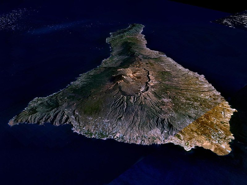
| ⴰⵎⵉⵔⴰⵏ | 02:15, 31 ⵎⴰⵕⵚ 2005 |  | 1 280 × 958 (120 KB) | Simplicius | {{NASA-PD}} Teneriffa from the west side. One sees Teide (3,700 meters) and the Caldera (2,000 m). To the right hand the new airport. On the left side one sees that there is more humidity and therefore vegetation at the north side of the island. |
ⴰⵙⵎⵔⵙ ⵏ ⵓⴼⴰⵢⵍⵓ
ⵜⴰⵙⵏⴰ ⴰⴷ ⵜⵙⵎⵔⵙ ⴰⴼⴰⵢⵍⵓ ⴰⴷ:
ⴰⵙⵎⵔⵙ ⴰⵖⵣⵓⵔⴰⵏ ⵏ ⵓⴼⴰⵢⵍⵓ
ⵉⵡⵉⴽⵉⵜⵏ ⴰⴷ ⵢⴰⴹⵏⵉⵏ ⴰⵔ ⵙⵙⵎⵔⵙⵏ ⴰⴼⴰⵢⵍⵓ ⴰⴷ:
- ⴰⵙⵎⵔⵙ ⴳ ar.wikipedia.org
- ⴰⵙⵎⵔⵙ ⴳ be-tarask.wikipedia.org
- ⴰⵙⵎⵔⵙ ⴳ cs.wikipedia.org
- ⴰⵙⵎⵔⵙ ⴳ de.wikipedia.org
- ⴰⵙⵎⵔⵙ ⴳ de.wikinews.org
- ⴰⵙⵎⵔⵙ ⴳ de.wikivoyage.org
- ⴰⵙⵎⵔⵙ ⴳ en.wiktionary.org
- ⴰⵙⵎⵔⵙ ⴳ eo.wikipedia.org
- ⴰⵙⵎⵔⵙ ⴳ es.wikipedia.org
- ⴰⵙⵎⵔⵙ ⴳ fa.wikipedia.org
- ⴰⵙⵎⵔⵙ ⴳ fi.wikipedia.org
- ⴰⵙⵎⵔⵙ ⴳ frr.wikipedia.org
- ⴰⵙⵎⵔⵙ ⴳ fy.wikipedia.org
- ⴰⵙⵎⵔⵙ ⴳ gl.wikipedia.org
- ⴰⵙⵎⵔⵙ ⴳ he.wikipedia.org
- ⴰⵙⵎⵔⵙ ⴳ hu.wikipedia.org
- ⴰⵙⵎⵔⵙ ⴳ incubator.wikimedia.org
- ⴰⵙⵎⵔⵙ ⴳ it.wikipedia.org
- ⴰⵙⵎⵔⵙ ⴳ mn.wikipedia.org
- ⴰⵙⵎⵔⵙ ⴳ nn.wikipedia.org
- ⴰⵙⵎⵔⵙ ⴳ no.wikipedia.org
- ⴰⵙⵎⵔⵙ ⴳ pl.wiktionary.org
- ⴰⵙⵎⵔⵙ ⴳ ru.wikipedia.org
- ⴰⵙⵎⵔⵙ ⴳ sh.wikipedia.org
- ⴰⵙⵎⵔⵙ ⴳ sk.wikipedia.org
- ⴰⵙⵎⵔⵙ ⴳ sw.wikipedia.org
- ⴰⵙⵎⵔⵙ ⴳ tr.wikipedia.org
- ⴰⵙⵎⵔⵙ ⴳ uk.wikipedia.org
- ⴰⵙⵎⵔⵙ ⴳ vi.wikivoyage.org

