
ⴰⴼⴰⵢⵍⵓ:MerguiArchipelagoMap.png
ⵜⵉⴷⴷⵉ ⵏ ⵜⵎⵓⵖⵍⵉ ⴰⴷ: 322 × 598 ⵉⴷ ⴱⵉⴽⵙⵍ. ⵜⵉⴼⵙⴰⵢⵉⵏ: ⵢⴰⴹⵏ 129 × 240 ⵉⴷ ⴱⵉⴽⵙⵍ | 258 × 480 ⵉⴷ ⴱⵉⴽⵙⵍ | 973 × 1 808 ⵉⴷ ⴱⵉⴽⵙⵍ.
ⴰⴼⴰⵢⵍⵓ ⴰⵙⴰⵍⴰⵏ (973 × 1 808 ⵉⴷ ⴱⵉⴽⵙⵍ, ⵜⵉⴷⴷⵉ ⵏ ⵓⴼⴰⵢⵍⵓ: 61 KB, ⴰⵏⴰⵡ MIME: image/png)
ⴰⵙⴳⵣⵍ
| ⴰⴳⵍⴰⵎ |
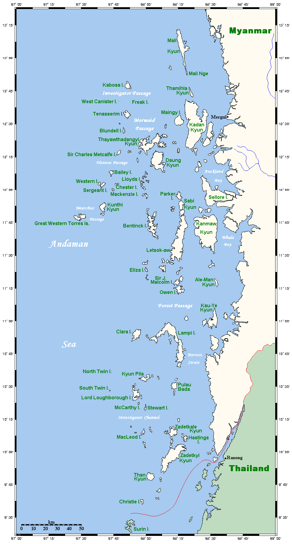
Map of the Mergui Archipelago in Myanmar. This map's source is here, with the uploader's modifications, and the GMT homepage says that the tools are released under the GNU General Public License. There is a somewhat bigger map of this area, showing places farther north and south. This is not on Wikipedia, but leave a message at my talk page if you would like such a thing, and likewise if you know any further information that ought to go on this map. |
| ⴰⵙⴰⴽⵓⴷ | 14 ⵎⴰⵢⵢⵓ 2006 (original upload date) |
| ⴰⵙⴰⴳⵎ | Transferred from en.wikipedia to Commons. |
| ⴰⵎⴳⴰⵢ | Kelisi at ⵜⴰⵏⴳⵍⵉⵣⵜ ⵡⵉⴽⵉⴱⵉⴷⵢⴰ |

|
This map image could be re-created using vector graphics as an SVG file. This has several advantages; see Commons:Media for cleanup for more information. If an SVG form of this image is available, please upload it and afterwards replace this template with
{{vector version available|new image name}}.
It is recommended to name the SVG file “MerguiArchipelagoMap.svg”—then the template Vector version available (or Vva) does not need the new image name parameter. |
ⵜⵓⵔⴰⴳⵜ
Kelisi from en.wikipedia.org, the copyright holder of this work, hereby publishes it under the following license:
| ⴰⴼⴰⵢⵍⵓ ⴰⴷ ⵉⵍⵍⴰ ⴷⴷⵓ ⵜⴼⴰⴷⵉⵡⵉⵏ ⵏⵜⵓⵔⴰⴳⵜ Creative Commons Attribution - Partage dans les Mêmes Conditions 3.0 (non transposée). Subject to disclaimers. | ||
| ⵜⵉⵡⵓⵔⵉⵡⵉⵏ: Kelisi from en.wikipedia.org | ||
| ||
| This licensing tag was added to this file as part of the GFDL licensing update. |

|
ⵖⵓⵔⴽ ⵜⵓⵔⴰⴳⵜ ⵏ ⴰⴷ ⵜⵙⵙⵏⵖⵍⴷ, ⴰⴷ ⵜⴱⴹⵓⴷ ⴷ ⴰⴷ ⵜⵙⵏⴼⵍⴷ ⵜⴰⵏⵜⴰⵎⵜ ⴰⴷ ⴷⴷⵓ ⵜⴼⴰⴷⵉⵡⵉⵏ ⵏ ⵜⵓⵔⴰⴳⵜ ⵊⵉⵏⵓ ⵉ ⵜⵏⵜⴰⵎⵉⵏ ⵜⵉⵍⴻⵍⵍⵉⵢⵉⵏ ⵜⵓⵏⵖⵉⵍⵜ 1.2 ⵏⵖ ⵜⵓⵏⵖⵉⵍⵜ ⵜⴰⵎⴰⵢⵏⵓⵜ ⴰⴽⴽ ⵏⵏⴰ ⵜⵥⵔⴳ ⵜⴰⵎⵔⵙⵍⵜ ⵏ ⵉⵙⵓⴼⵜⵡⵓⵔⵏ ⵉⵍⴻⵍⵍⵉⵢⵏ, ⵎⵉⵏ ⵜⵉⵣⵓⵏⵉⵡⵉⵏ ⴰⵔⵎⵙⴽⵉⵍⵏ, ⵎⵉⵏ ⴰⴹⵔⵉⵙ ⵏ ⵜⴰⵙⵏⴰ ⵜⴰⵎⵣⵡⴰⵔⵓⵜ ⵏ ⵜⴷⵓⵍⵉ ⴷ ⵎⵉⵏ ⴰⴹⵔⵉⵙ ⵏ ⵜⴰⵙⵏⴰ ⵜⴰⵎⴳⴳⴰⵔⵓⵜ ⵏ ⵜⴷⵓⵍⵉ.ⵢⴰⵜ ⵜⵓⵏⵖⵉⵍⵜ ⵏ ⵜⵓⵔⴰⴳⵜ ⵜⴽⵛⵎ ⴳ ⵜⵣⵓⵏⵉ ⵉⵍⴰⵏ ⴰⵣⵡⵍ GNU Free Documentation License. Subject to disclaimers. |
Original upload log
The original description page was here. All following user names refer to en.wikipedia.
- 2006-05-14 20:32 Kelisi 973×1808×8 (62506 bytes) Map of the Mergui Archipelago in Myanmar. This map's source is [http://www.aquarius.geomar.de/omc/make_map.html here], with the uploader's modifications, and the [http://gmt.soest.hawaii.edu/ GMT homepage] says that the tools are released under the GNU Ge
ⴰⵎⵣⵔⵓⵢ ⵏ ⵓⴼⴰⵢⵍⵓ
ⴽⵍⵉⴽⵉ ⵖⴼ ⵓⵙⴰⴽⵓⴷ/ⴰⴽⵓⴷ ⵃⵎⴰ ⴰⴷ ⵜⵙⴽⵏⴷ ⴰⴼⴰⵢⵍⵓ ⵎⴰⵏⵎⴽ ⴰⴷ ⵢⴰⴷⵍⵍⵉ ⵉⴳⴰ ⴳ ⵡⴰⴽⵓⴷ ⴰⵏⵏ.
| ⴰⵙⴰⴽⵓⴷ/ⴰⴽⵓⴷ | ⵜⴰⵡⵍⴰⴼⵜ ⵎⵥⵥⵉⵢⵏ | ⵉⵎⵏⴰⴷⵏ | ⴰⵏⵙⵙⵎⵔⵙ | ⴰⵖⴼⴰⵡⴰⵍ | |
|---|---|---|---|---|---|
| ⴰⵎⵉⵔⴰⵏ | 00:20, 2 ⵎⴰⵢⵢⵓ 2007 | | 973 × 1 808 (61 KB) | Ppntori | {{Information |Description=Map of the Mergui Archipelago in Myanmar. This map's source is [http://www.aquarius.geomar.de/omc/make_map.html here], with the uploader's modifications, and the [http://gmt.soest.hawaii.edu/ GMT homepage] says that the tools ar |
ⴰⵙⵎⵔⵙ ⵏ ⵓⴼⴰⵢⵍⵓ
ⵜⴰⵙⵏⴰ ⴰⴷ ⵜⵙⵎⵔⵙ ⴰⴼⴰⵢⵍⵓ ⴰⴷ:
ⴰⵙⵎⵔⵙ ⴰⵖⵣⵓⵔⴰⵏ ⵏ ⵓⴼⴰⵢⵍⵓ
ⵉⵡⵉⴽⵉⵜⵏ ⴰⴷ ⵢⴰⴹⵏⵉⵏ ⴰⵔ ⵙⵙⵎⵔⵙⵏ ⴰⴼⴰⵢⵍⵓ ⴰⴷ:
- ⴰⵙⵎⵔⵙ ⴳ ar.wikipedia.org
- ⴰⵙⵎⵔⵙ ⴳ arz.wikipedia.org
- ⴰⵙⵎⵔⵙ ⴳ ban.wikipedia.org
- ⴰⵙⵎⵔⵙ ⴳ bcl.wikipedia.org
- ⴰⵙⵎⵔⵙ ⴳ bg.wikipedia.org
- ⴰⵙⵎⵔⵙ ⴳ bh.wikipedia.org
- ⴰⵙⵎⵔⵙ ⴳ bn.wikipedia.org
- ⴰⵙⵎⵔⵙ ⴳ bs.wikipedia.org
- ⴰⵙⵎⵔⵙ ⴳ ca.wikipedia.org
- ⴰⵙⵎⵔⵙ ⴳ ckb.wikipedia.org
- ⴰⵙⵎⵔⵙ ⴳ cy.wikipedia.org
- ⴰⵙⵎⵔⵙ ⴳ de.wikipedia.org
- ⴰⵙⵎⵔⵙ ⴳ en.wikipedia.org
- ⴰⵙⵎⵔⵙ ⴳ es.wikipedia.org
- ⴰⵙⵎⵔⵙ ⴳ fa.wikipedia.org
- ⴰⵙⵎⵔⵙ ⴳ fi.wikipedia.org
- ⴰⵙⵎⵔⵙ ⴳ fr.wikipedia.org
- ⴰⵙⵎⵔⵙ ⴳ fy.wikipedia.org
- ⴰⵙⵎⵔⵙ ⴳ ga.wikipedia.org
- ⴰⵙⵎⵔⵙ ⴳ hi.wikipedia.org
- ⴰⵙⵎⵔⵙ ⴳ hu.wikipedia.org
- ⴰⵙⵎⵔⵙ ⴳ ia.wikipedia.org
- ⴰⵙⵎⵔⵙ ⴳ id.wikipedia.org
- ⴰⵙⵎⵔⵙ ⴳ ilo.wikipedia.org
- ⴰⵙⵎⵔⵙ ⴳ incubator.wikimedia.org
- ⴰⵙⵎⵔⵙ ⴳ io.wikipedia.org
- ⴰⵙⵎⵔⵙ ⴳ it.wikipedia.org
- ⴰⵙⵎⵔⵙ ⴳ ja.wikipedia.org
- ⴰⵙⵎⵔⵙ ⴳ jv.wikipedia.org
- ⴰⵙⵎⵔⵙ ⴳ kk.wikipedia.org
- ⴰⵙⵎⵔⵙ ⴳ km.wikipedia.org
- ⴰⵙⵎⵔⵙ ⴳ kn.wikipedia.org
- ⴰⵙⵎⵔⵙ ⴳ ko.wikipedia.org
- ⴰⵙⵎⵔⵙ ⴳ lt.wikipedia.org
- ⴰⵙⵎⵔⵙ ⴳ min.wikipedia.org
- ⴰⵙⵎⵔⵙ ⴳ mk.wikipedia.org
- ⴰⵙⵎⵔⵙ ⴳ ml.wikipedia.org
ⵙⴽⵏ ⵓⴳⴳⴰⵔ ⵖⴼ ⵓⵙⵙⵎⵔⵙ ⴰⵎⴰⵜⴰⵢ ⵏ ⵓⴼⴰⵢⵍⵓ ⴰⴷ.