
ⴰⴼⴰⵢⵍⵓ:Mapa Canarias Tenerife.svg

Size of this PNG preview of this SVG file: 800 × 336 ⵉⴷ ⴱⵉⴽⵙⵍ. ⵜⵉⴼⵙⴰⵢⵉⵏ: ⵢⴰⴹⵏ 320 × 134 ⵉⴷ ⴱⵉⴽⵙⵍ | 640 × 269 ⵉⴷ ⴱⵉⴽⵙⵍ | 1 024 × 430 ⵉⴷ ⴱⵉⴽⵙⵍ | 1 280 × 537 ⵉⴷ ⴱⵉⴽⵙⵍ | 2 560 × 1 074 ⵉⴷ ⴱⵉⴽⵙⵍ | 977 × 410 ⵉⴷ ⴱⵉⴽⵙⵍ.
ⴰⴼⴰⵢⵍⵓ ⴰⵙⴰⵍⴰⵏ (ⴰⴼⴰⵢⵍⵓ SVG, ⵙ 977 × 410 ⵉⴷ ⴱⵉⴽⵙⵍ, ⵜⵉⴷⴷⵉ ⵏ ⵓⴼⴰⵢⵍⵓ: 27 KB)
ⴰⵙⴳⵣⵍ
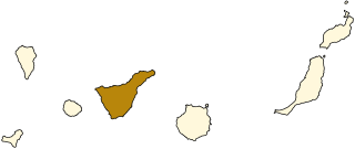
| ⴰⴳⵍⴰⵎ | Map of Lanzarote, Canary Islands. |
| ⴰⵙⴰⴽⵓⴷ | |
| ⴰⵙⴰⴳⵎ | Image:Mapa Canarias.svg |
| ⴰⵎⴳⴰⵢ | Júlio Reis |
ⵜⵓⵔⴰⴳⵜ
ⴰⴼⴰⵢⵍⵓ ⴰⴷ ⵉⵍⵍⴰ ⴷⴷⵓ ⵜⴼⴰⴷⵉⵡⵉⵏ ⵏⵜⵓⵔⴰⴳⵜ Creative Commons Attribution - Partage dans les Mêmes Conditions 3.0 (non transposée).
- ⵜⴳⵉⴷ ⵉⵍⴻⵍⵍⵉ:
- ⴱⴹⵓ – ⵉ ⵓⵙⵙⵏⵖⵍ, ⴰⴱⵟⵟⵓ ⴷ ⵓⵙⵎⵓⵜⵜⵢ ⵏ ⵜⵡⵓⵔⵉ
- ⵛⵛⴰⵔ – ⵉ ⵓⵙⵎⵙⴰⵙⴰ ⵏ ⵜⵡⵓⵔⵉ
- ⴷⴷⴰⵡ ⵜⴼⴰⴷⵉⵡⵉⵏ ⴰⴷ:
- ⴰⵎⴰⵙ – ⵉⵇⵇⴰⵏ ⴷ ⴰⴷ ⵜⴼⴽⴷ ⵓⵎⵍⴰⵏ ⵖⴼ ⵓⵎⴳⴰⵢ, ⵜⴼⴽⴷ ⴰⵙⵖⵏ ⵖⵔ ⵜⵓⵔⴰⴳⵜ, ⵜⵎⵍⴷ ⵉⵖ ⵉⵜⵜⵡⴰⵙⵏⴼⵍ. ⵜⵣⴹⴰⵔⴷ ⴰⴷ ⵜⵙⴽⵔⴷ ⵎⴽ ⴰⴷ ⵙ ⵜⵖⴰⵔⴰⵙⵜ ⵏⵏⴰ ⴷ ⵢⵓⵙⴰⵏ, ⵎⴰⵛ ⵓⵔ ⴷ ⴽⵔⴰ ⵏ ⵜⵖⴰⵔⴰⵙⵜ ⵉⵎⵎⴰⵍⵏ ⵎⴰ ⵙ ⴷ ⴰⵎⴳⴰⵢ ⴰⵔ ⴽ ⵉⵏⵏⴰⵍ ⵏⵖ ⴷ ⴰⵙⵎⵔⵙ ⵏⴽ.
- ⴱⴹⵓⵜ ⵎⴽⵍⵍⵉⵜ – ⵎⴽ ⵜⵙⵏⴼⵍⴷ ⵏⵖ ⵜⵙⵎⵓⵜⵜⵉⴷ ⵏⵖ ⵜⵥⴽⵉⴷ ⵖⴼ ⵜⵡⵓⵔⵉ, ⵉⵇⵇⴰⵏⴽ ⵉⴷ ⴰⴷ ⵜⴱⴹⵓⴷ ⵜⵓⵎⵓⵜⵉⵏ ⵏⴽ ⴷⴷⴰⵡ ⵜⵓⵔⴰⵇⵜ ⴰⵏⵏ ⵏⵉⵜ ⵏⵖ ⴽⵔⴰ ⵏ ⵜⵓⵔⴰⴳⵜ ⴷ ⵢⵓⵙⴰⵏ ⴷ ⵜⴷⵙⵍⴰⵏⵜ.
ⴰⵎⵣⵔⵓⵢ ⵏ ⵓⴼⴰⵢⵍⵓ
ⴽⵍⵉⴽⵉ ⵖⴼ ⵓⵙⴰⴽⵓⴷ/ⴰⴽⵓⴷ ⵃⵎⴰ ⴰⴷ ⵜⵙⴽⵏⴷ ⴰⴼⴰⵢⵍⵓ ⵎⴰⵏⵎⴽ ⴰⴷ ⵢⴰⴷⵍⵍⵉ ⵉⴳⴰ ⴳ ⵡⴰⴽⵓⴷ ⴰⵏⵏ.
| ⴰⵙⴰⴽⵓⴷ/ⴰⴽⵓⴷ | ⵜⴰⵡⵍⴰⴼⵜ ⵎⵥⵥⵉⵢⵏ | ⵉⵎⵏⴰⴷⵏ | ⴰⵏⵙⵙⵎⵔⵙ | ⴰⵖⴼⴰⵡⴰⵍ | |
|---|---|---|---|---|---|
| ⴰⵎⵉⵔⴰⵏ | 18:39, 19 ⵢⵓⵍⵢⵓⵣ 2006 | | 977 × 410 (27 KB) | Tintazul | {{Tintazul |Description=Map of Lanzarote, Canary Islands. |Source=Image:Mapa Canarias.svg |Date=19 July 2006 }} Category:Maps of the Canary Islands |
ⴰⵙⵎⵔⵙ ⵏ ⵓⴼⴰⵢⵍⵓ
ⵜⴰⵙⵏⴰ ⴰⴷ ⵜⵙⵎⵔⵙ ⴰⴼⴰⵢⵍⵓ ⴰⴷ:
ⴰⵙⵎⵔⵙ ⴰⵖⵣⵓⵔⴰⵏ ⵏ ⵓⴼⴰⵢⵍⵓ
ⵉⵡⵉⴽⵉⵜⵏ ⴰⴷ ⵢⴰⴹⵏⵉⵏ ⴰⵔ ⵙⵙⵎⵔⵙⵏ ⴰⴼⴰⵢⵍⵓ ⴰⴷ:
- ⴰⵙⵎⵔⵙ ⴳ af.wikipedia.org
- ⴰⵙⵎⵔⵙ ⴳ an.wikipedia.org
- ⴰⵙⵎⵔⵙ ⴳ ca.wikipedia.org
- ⴰⵙⵎⵔⵙ ⴳ de.wiktionary.org
- ⴰⵙⵎⵔⵙ ⴳ eo.wikipedia.org
- ⴰⵙⵎⵔⵙ ⴳ fr.wikipedia.org
- El Rosario (Tenerife)
- Candelaria (Tenerife)
- Santa Cruz de Tenerife
- Icod de los Vinos
- Adeje
- Arona (Tenerife)
- Arafo
- Vilaflor de Chasna
- Tegueste
- Buenavista del Norte
- Fasnia
- Garachico
- Granadilla de Abona
- Puerto de la Cruz
- La Guancha
- Guía de Isora
- Güímar
- La Matanza de Acentejo
- El Tanque
- La Victoria de Acentejo
- San Cristóbal de La Laguna
- Los Realejos
- San Juan de la Rambla
- Santa Úrsula (Tenerife)
- Santiago del Teide
- El Sauzal (Tenerife)
- Los Silos
- Tacoronte
- San Miguel de Abona
- La Orotava
- Arico
- Circonscription électorale de Tenerife
- ⴰⵙⵎⵔⵙ ⴳ fy.wikipedia.org
- ⴰⵙⵎⵔⵙ ⴳ gl.wikipedia.org
- ⴰⵙⵎⵔⵙ ⴳ hu.wikipedia.org
- ⴰⵙⵎⵔⵙ ⴳ incubator.wikimedia.org
- ⴰⵙⵎⵔⵙ ⴳ la.wikipedia.org
- ⴰⵙⵎⵔⵙ ⴳ mn.wikipedia.org
- ⴰⵙⵎⵔⵙ ⴳ mr.wikipedia.org
- ⴰⵙⵎⵔⵙ ⴳ no.wikipedia.org
- ⴰⵙⵎⵔⵙ ⴳ oc.wikipedia.org
- ⴰⵙⵎⵔⵙ ⴳ pl.wikivoyage.org
- ⴰⵙⵎⵔⵙ ⴳ sc.wikipedia.org
- ⴰⵙⵎⵔⵙ ⴳ zh.wikipedia.org