
ⴰⴼⴰⵢⵍⵓ:Kidal topographic map-fr.svg

Size of this PNG preview of this SVG file: 800 × 518 ⵉⴷ ⴱⵉⴽⵙⵍ. ⵜⵉⴼⵙⴰⵢⵉⵏ: ⵢⴰⴹⵏ 320 × 207 ⵉⴷ ⴱⵉⴽⵙⵍ | 640 × 414 ⵉⴷ ⴱⵉⴽⵙⵍ | 1 024 × 663 ⵉⴷ ⴱⵉⴽⵙⵍ | 1 280 × 829 ⵉⴷ ⴱⵉⴽⵙⵍ | 2 560 × 1 658 ⵉⴷ ⴱⵉⴽⵙⵍ | 6 200 × 4 015 ⵉⴷ ⴱⵉⴽⵙⵍ.
ⴰⴼⴰⵢⵍⵓ ⴰⵙⴰⵍⴰⵏ (ⴰⴼⴰⵢⵍⵓ SVG, ⵙ 6 200 × 4 015 ⵉⴷ ⴱⵉⴽⵙⵍ, ⵜⵉⴷⴷⵉ ⵏ ⵓⴼⴰⵢⵍⵓ: 3,54 MB)
ⴰⵙⴳⵣⵍ
| Camera location | | View this and other nearby images on: OpenStreetMap |
|---|
| ⴰⴳⵍⴰⵎ |
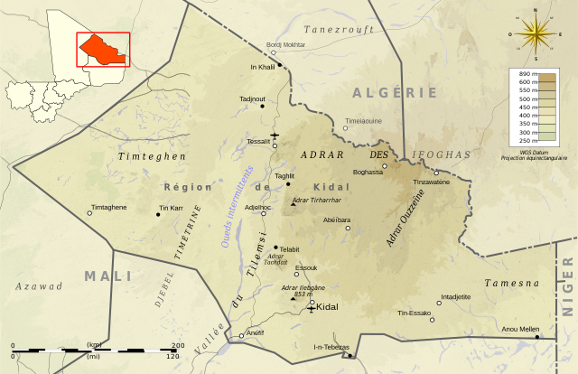
Deutsch: Topographische Karte des Region kidal, in Französische.
English: Topographic map in French language of Kidal Region.
Español: Mapa topográfico en francès de Kidal.
Italiano: Mappa topografica della Regione di Kidal (en francese).
日本語: フランス語で表示したキダル州の地形図。
Português: Carta topográfica do Kidal em francês.
|
||
| ⴰⵙⴰⴽⵓⴷ | (UTC) | ||
| ⴰⵙⴰⴳⵎ |
Création personnelle ;
|
||
| ⴰⵎⴳⴰⵢ | © Bourrichon (talk) - fr:Bourrichon | ||
| ⵜⵓⵔⴰⴳⵜ (ⵙⵙⵎⵔⵙ ⴷⴰⵖ ⴰⴼⴰⵢⵍⵓ ⴰ) |
|
||
| Other versions | File:Kidal administrative map-fr.svg |

|
This SVG file contains embedded text that can be translated into your language, using any capable SVG editor, text editor or the SVG Translate tool. For more information see: About translating SVG files. |
This W3C-unspecified vector image was created with Inkscape .
ⵜⵓⵔⴰⴳⵜ
I, the copyright holder of this work, hereby publish it under the following licenses:

|
ⵖⵓⵔⴽ ⵜⵓⵔⴰⴳⵜ ⵏ ⴰⴷ ⵜⵙⵙⵏⵖⵍⴷ, ⴰⴷ ⵜⴱⴹⵓⴷ ⴷ ⴰⴷ ⵜⵙⵏⴼⵍⴷ ⵜⴰⵏⵜⴰⵎⵜ ⴰⴷ ⴷⴷⵓ ⵜⴼⴰⴷⵉⵡⵉⵏ ⵏ ⵜⵓⵔⴰⴳⵜ ⵊⵉⵏⵓ ⵉ ⵜⵏⵜⴰⵎⵉⵏ ⵜⵉⵍⴻⵍⵍⵉⵢⵉⵏ ⵜⵓⵏⵖⵉⵍⵜ 1.2 ⵏⵖ ⵜⵓⵏⵖⵉⵍⵜ ⵜⴰⵎⴰⵢⵏⵓⵜ ⴰⴽⴽ ⵏⵏⴰ ⵜⵥⵔⴳ ⵜⴰⵎⵔⵙⵍⵜ ⵏ ⵉⵙⵓⴼⵜⵡⵓⵔⵏ ⵉⵍⴻⵍⵍⵉⵢⵏ, ⵎⵉⵏ ⵜⵉⵣⵓⵏⵉⵡⵉⵏ ⴰⵔⵎⵙⴽⵉⵍⵏ, ⵎⵉⵏ ⴰⴹⵔⵉⵙ ⵏ ⵜⴰⵙⵏⴰ ⵜⴰⵎⵣⵡⴰⵔⵓⵜ ⵏ ⵜⴷⵓⵍⵉ ⴷ ⵎⵉⵏ ⴰⴹⵔⵉⵙ ⵏ ⵜⴰⵙⵏⴰ ⵜⴰⵎⴳⴳⴰⵔⵓⵜ ⵏ ⵜⴷⵓⵍⵉ.ⵢⴰⵜ ⵜⵓⵏⵖⵉⵍⵜ ⵏ ⵜⵓⵔⴰⴳⵜ ⵜⴽⵛⵎ ⴳ ⵜⵣⵓⵏⵉ ⵉⵍⴰⵏ ⴰⵣⵡⵍ GNU Free Documentation License. |
This file is licensed under the Creative Commons Attribution-Share Alike 3.0 Unported, 2.5 Generic, 2.0 Generic and 1.0 Generic license.
- ⵜⴳⵉⴷ ⵉⵍⴻⵍⵍⵉ:
- ⴱⴹⵓ – ⵉ ⵓⵙⵙⵏⵖⵍ, ⴰⴱⵟⵟⵓ ⴷ ⵓⵙⵎⵓⵜⵜⵢ ⵏ ⵜⵡⵓⵔⵉ
- ⵛⵛⴰⵔ – ⵉ ⵓⵙⵎⵙⴰⵙⴰ ⵏ ⵜⵡⵓⵔⵉ
- ⴷⴷⴰⵡ ⵜⴼⴰⴷⵉⵡⵉⵏ ⴰⴷ:
- ⴰⵎⴰⵙ – ⵉⵇⵇⴰⵏ ⴷ ⴰⴷ ⵜⴼⴽⴷ ⵓⵎⵍⴰⵏ ⵖⴼ ⵓⵎⴳⴰⵢ, ⵜⴼⴽⴷ ⴰⵙⵖⵏ ⵖⵔ ⵜⵓⵔⴰⴳⵜ, ⵜⵎⵍⴷ ⵉⵖ ⵉⵜⵜⵡⴰⵙⵏⴼⵍ. ⵜⵣⴹⴰⵔⴷ ⴰⴷ ⵜⵙⴽⵔⴷ ⵎⴽ ⴰⴷ ⵙ ⵜⵖⴰⵔⴰⵙⵜ ⵏⵏⴰ ⴷ ⵢⵓⵙⴰⵏ, ⵎⴰⵛ ⵓⵔ ⴷ ⴽⵔⴰ ⵏ ⵜⵖⴰⵔⴰⵙⵜ ⵉⵎⵎⴰⵍⵏ ⵎⴰ ⵙ ⴷ ⴰⵎⴳⴰⵢ ⴰⵔ ⴽ ⵉⵏⵏⴰⵍ ⵏⵖ ⴷ ⴰⵙⵎⵔⵙ ⵏⴽ.
- ⴱⴹⵓⵜ ⵎⴽⵍⵍⵉⵜ – ⵎⴽ ⵜⵙⵏⴼⵍⴷ ⵏⵖ ⵜⵙⵎⵓⵜⵜⵉⴷ ⵏⵖ ⵜⵥⴽⵉⴷ ⵖⴼ ⵜⵡⵓⵔⵉ, ⵉⵇⵇⴰⵏⴽ ⵉⴷ ⴰⴷ ⵜⴱⴹⵓⴷ ⵜⵓⵎⵓⵜⵉⵏ ⵏⴽ ⴷⴷⴰⵡ ⵜⵓⵔⴰⵇⵜ ⴰⵏⵏ ⵏⵉⵜ ⵏⵖ ⴽⵔⴰ ⵏ ⵜⵓⵔⴰⴳⵜ ⴷ ⵢⵓⵙⴰⵏ ⴷ ⵜⴷⵙⵍⴰⵏⵜ.
ⵜⵣⵎⵔⴷ ⴰⴷ ⵜⵙⵜⵉⴷ ⵜⵓⵔⴰⴳⵜ ⵏⵏⴰ ⵜⵔⵉⴷ.
ⴰⵎⵣⵔⵓⵢ ⵏ ⵓⴼⴰⵢⵍⵓ
ⴽⵍⵉⴽⵉ ⵖⴼ ⵓⵙⴰⴽⵓⴷ/ⴰⴽⵓⴷ ⵃⵎⴰ ⴰⴷ ⵜⵙⴽⵏⴷ ⴰⴼⴰⵢⵍⵓ ⵎⴰⵏⵎⴽ ⴰⴷ ⵢⴰⴷⵍⵍⵉ ⵉⴳⴰ ⴳ ⵡⴰⴽⵓⴷ ⴰⵏⵏ.
| ⴰⵙⴰⴽⵓⴷ/ⴰⴽⵓⴷ | ⵜⴰⵡⵍⴰⴼⵜ ⵎⵥⵥⵉⵢⵏ | ⵉⵎⵏⴰⴷⵏ | ⴰⵏⵙⵙⵎⵔⵙ | ⴰⵖⴼⴰⵡⴰⵍ | |
|---|---|---|---|---|---|
| ⴰⵎⵉⵔⴰⵏ | 02:54, 3 ⵎⴰⵕⵚ 2013 | | 6 200 × 4 015 (3,54 MB) | Bourrichon | correction scale |
| 02:35, 3 ⵎⴰⵕⵚ 2013 |  | 6 200 × 4 015 (3,54 MB) | Bourrichon | ||
| 02:32, 3 ⵎⴰⵕⵚ 2013 |  | 6 200 × 4 015 (3,53 MB) | Bourrichon | == {{int:filedesc}} == {{Location|19|46|00|N|01|25|00|E|scale:500000}} {{Information |Description= {{fr|Carte topographique en français de la région de Kidal, au fr:Mali.}} {{de|Topographische Karte des [[:de:Region kid... |
ⴰⵙⵎⵔⵙ ⵏ ⵓⴼⴰⵢⵍⵓ
ⵜⴰⵙⵏⴰ ⴰⴷ ⵜⵙⵎⵔⵙ ⴰⴼⴰⵢⵍⵓ ⴰⴷ:
ⴰⵙⵎⵔⵙ ⴰⵖⵣⵓⵔⴰⵏ ⵏ ⵓⴼⴰⵢⵍⵓ
ⵉⵡⵉⴽⵉⵜⵏ ⴰⴷ ⵢⴰⴹⵏⵉⵏ ⴰⵔ ⵙⵙⵎⵔⵙⵏ ⴰⴼⴰⵢⵍⵓ ⴰⴷ:
- ⴰⵙⵎⵔⵙ ⴳ ar.wikipedia.org
- ⴰⵙⵎⵔⵙ ⴳ de.wikipedia.org
- ⴰⵙⵎⵔⵙ ⴳ en.wikipedia.org
- ⴰⵙⵎⵔⵙ ⴳ fa.wikipedia.org
- ⴰⵙⵎⵔⵙ ⴳ fi.wikipedia.org
- ⴰⵙⵎⵔⵙ ⴳ fr.wikipedia.org
- ⴰⵙⵎⵔⵙ ⴳ hu.wikipedia.org
- ⴰⵙⵎⵔⵙ ⴳ ja.wikipedia.org
- ⴰⵙⵎⵔⵙ ⴳ shi.wikipedia.org
- ⴰⵙⵎⵔⵙ ⴳ zh.wikipedia.org