
ⴰⴼⴰⵢⵍⵓ:Hafsid1400.png
ⵓⵔ ⵜⵍⵍⵉ ⵜⵙⴷⴷⵉ ⵉⵎⵇⵇⵓⵔⵏ ⵓⴳⴳⴰⵔ
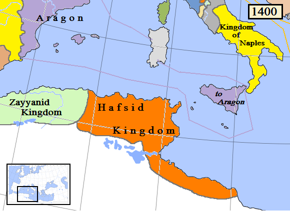
Hafsid1400.png (580 × 423 ⵉⴷ ⴱⵉⴽⵙⵍ, ⵜⵉⴷⴷⵉ ⵏ ⵓⴼⴰⵢⵍⵓ: 61 KB, ⴰⵏⴰⵡ MIME: image/png)
ⴰⵙⴳⵣⵍ
| ⴰⴳⵍⴰⵎ |
English: Map of the Hafsid dynasty/kingdom in North Africa, AD 1400. (Partially based on Euratlas map of Europe 1400.) |
| ⴰⵙⴰⴽⵓⴷ | |
| ⴰⵙⴰⴳⵎ | ⵜⴰⵡⵡⵓⵔⵉ ⵜⴰⵏⵉⵎⴰⵏⵜ |
| ⴰⵎⴳⴰⵢ | Gabagool |
ⵜⵓⵔⴰⴳⵜ
I, the copyright holder of this work, hereby publish it under the following license:
This file is licensed under the Creative Commons Attribution 3.0 Unported license.
- ⵜⴳⵉⴷ ⵉⵍⴻⵍⵍⵉ:
- ⴱⴹⵓ – ⵉ ⵓⵙⵙⵏⵖⵍ, ⴰⴱⵟⵟⵓ ⴷ ⵓⵙⵎⵓⵜⵜⵢ ⵏ ⵜⵡⵓⵔⵉ
- ⵛⵛⴰⵔ – ⵉ ⵓⵙⵎⵙⴰⵙⴰ ⵏ ⵜⵡⵓⵔⵉ
- ⴷⴷⴰⵡ ⵜⴼⴰⴷⵉⵡⵉⵏ ⴰⴷ:
- ⴰⵎⴰⵙ – ⵉⵇⵇⴰⵏ ⴷ ⴰⴷ ⵜⴼⴽⴷ ⵓⵎⵍⴰⵏ ⵖⴼ ⵓⵎⴳⴰⵢ, ⵜⴼⴽⴷ ⴰⵙⵖⵏ ⵖⵔ ⵜⵓⵔⴰⴳⵜ, ⵜⵎⵍⴷ ⵉⵖ ⵉⵜⵜⵡⴰⵙⵏⴼⵍ. ⵜⵣⴹⴰⵔⴷ ⴰⴷ ⵜⵙⴽⵔⴷ ⵎⴽ ⴰⴷ ⵙ ⵜⵖⴰⵔⴰⵙⵜ ⵏⵏⴰ ⴷ ⵢⵓⵙⴰⵏ, ⵎⴰⵛ ⵓⵔ ⴷ ⴽⵔⴰ ⵏ ⵜⵖⴰⵔⴰⵙⵜ ⵉⵎⵎⴰⵍⵏ ⵎⴰ ⵙ ⴷ ⴰⵎⴳⴰⵢ ⴰⵔ ⴽ ⵉⵏⵏⴰⵍ ⵏⵖ ⴷ ⴰⵙⵎⵔⵙ ⵏⴽ.
ⴰⵎⵣⵔⵓⵢ ⵏ ⵓⴼⴰⵢⵍⵓ
ⴽⵍⵉⴽⵉ ⵖⴼ ⵓⵙⴰⴽⵓⴷ/ⴰⴽⵓⴷ ⵃⵎⴰ ⴰⴷ ⵜⵙⴽⵏⴷ ⴰⴼⴰⵢⵍⵓ ⵎⴰⵏⵎⴽ ⴰⴷ ⵢⴰⴷⵍⵍⵉ ⵉⴳⴰ ⴳ ⵡⴰⴽⵓⴷ ⴰⵏⵏ.
| ⴰⵙⴰⴽⵓⴷ/ⴰⴽⵓⴷ | ⵜⴰⵡⵍⴰⴼⵜ ⵎⵥⵥⵉⵢⵏ | ⵉⵎⵏⴰⴷⵏ | ⴰⵏⵙⵙⵎⵔⵙ | ⴰⵖⴼⴰⵡⴰⵍ | |
|---|---|---|---|---|---|
| ⴰⵎⵉⵔⴰⵏ | 14:49, 29 ⵎⴰⵕⵚ 2009 | | 580 × 423 (61 KB) | Gabagool | {{Information |Description={{en|1=Map of the Hafsid dynasty/kingdom in North Africa, AD 1400.}} |Source=Own work by uploader |Author=Gabagool |Date=2009-03-29 |Permission= |other_versions= }} Partially based on Euratlas map of Europe 140 |
ⴰⵙⵎⵔⵙ ⵏ ⵓⴼⴰⵢⵍⵓ
ⵜⴰⵙⵏⴰ ⴰⴷ ⵜⵙⵎⵔⵙ ⴰⴼⴰⵢⵍⵓ ⴰⴷ:
ⴰⵙⵎⵔⵙ ⴰⵖⵣⵓⵔⴰⵏ ⵏ ⵓⴼⴰⵢⵍⵓ
ⵉⵡⵉⴽⵉⵜⵏ ⴰⴷ ⵢⴰⴹⵏⵉⵏ ⴰⵔ ⵙⵙⵎⵔⵙⵏ ⴰⴼⴰⵢⵍⵓ ⴰⴷ:
- ⴰⵙⵎⵔⵙ ⴳ ar.wikipedia.org
- ⴰⵙⵎⵔⵙ ⴳ ast.wikipedia.org
- ⴰⵙⵎⵔⵙ ⴳ azb.wikipedia.org
- ⴰⵙⵎⵔⵙ ⴳ az.wikipedia.org
- ⴰⵙⵎⵔⵙ ⴳ be.wikipedia.org
- ⴰⵙⵎⵔⵙ ⴳ bn.wikipedia.org
- ⴰⵙⵎⵔⵙ ⴳ ca.wikipedia.org
- ⴰⵙⵎⵔⵙ ⴳ cs.wikipedia.org
- ⴰⵙⵎⵔⵙ ⴳ da.wikipedia.org
- ⴰⵙⵎⵔⵙ ⴳ en.wikipedia.org
- ⴰⵙⵎⵔⵙ ⴳ eo.wikipedia.org
- ⴰⵙⵎⵔⵙ ⴳ es.wikipedia.org
- ⴰⵙⵎⵔⵙ ⴳ et.wikipedia.org
- ⴰⵙⵎⵔⵙ ⴳ fa.wikipedia.org
- ⴰⵙⵎⵔⵙ ⴳ fi.wikipedia.org
- ⴰⵙⵎⵔⵙ ⴳ fr.wikipedia.org
- ⴰⵙⵎⵔⵙ ⴳ he.wikipedia.org
- ⴰⵙⵎⵔⵙ ⴳ hi.wikipedia.org
- ⴰⵙⵎⵔⵙ ⴳ hu.wikipedia.org
- ⴰⵙⵎⵔⵙ ⴳ id.wikipedia.org
- ⴰⵙⵎⵔⵙ ⴳ id.wikibooks.org
- ⴰⵙⵎⵔⵙ ⴳ incubator.wikimedia.org
- ⴰⵙⵎⵔⵙ ⴳ it.wikipedia.org
- ⴰⵙⵎⵔⵙ ⴳ ja.wikipedia.org
ⵙⴽⵏ ⵓⴳⴳⴰⵔ ⵖⴼ ⵓⵙⵙⵎⵔⵙ ⴰⵎⴰⵜⴰⵢ ⵏ ⵓⴼⴰⵢⵍⵓ ⴰⴷ.