
ⴰⴼⴰⵢⵍⵓ:EU-Croatia.svg

Size of this PNG preview of this SVG file: 713 × 600 ⵉⴷ ⴱⵉⴽⵙⵍ. ⵜⵉⴼⵙⴰⵢⵉⵏ: ⵢⴰⴹⵏ 285 × 240 ⵉⴷ ⴱⵉⴽⵙⵍ | 571 × 480 ⵉⴷ ⴱⵉⴽⵙⵍ | 913 × 768 ⵉⴷ ⴱⵉⴽⵙⵍ | 1 218 × 1 024 ⵉⴷ ⴱⵉⴽⵙⵍ | 2 435 × 2 048 ⵉⴷ ⴱⵉⴽⵙⵍ | 2 045 × 1 720 ⵉⴷ ⴱⵉⴽⵙⵍ.
ⴰⴼⴰⵢⵍⵓ ⴰⵙⴰⵍⴰⵏ (ⴰⴼⴰⵢⵍⵓ SVG, ⵙ 2 045 × 1 720 ⵉⴷ ⴱⵉⴽⵙⵍ, ⵜⵉⴷⴷⵉ ⵏ ⵓⴼⴰⵢⵍⵓ: 7,33 MB)
ⴰⵙⴳⵣⵍ
| ⴰⴳⵍⴰⵎ |
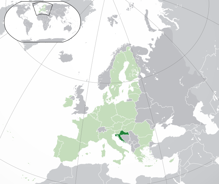
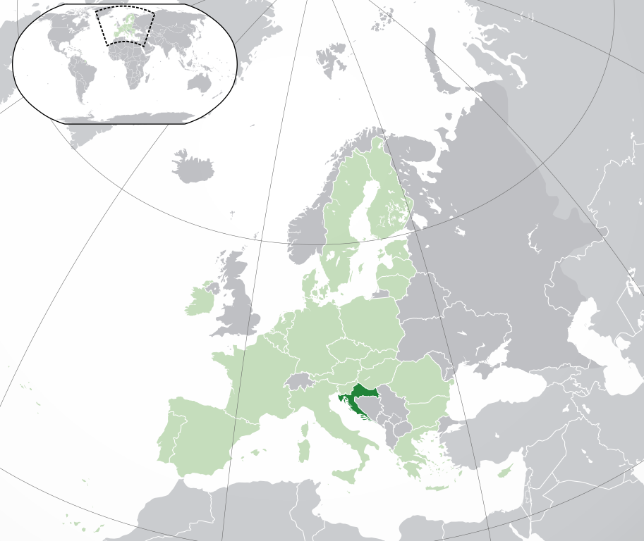
Français : (Vert) Croatie
(Vert clair) : Union Européenne (UE) (Gris) : Europe (Gris clair) : Région avoisinanteEnglish: (Green) : Croatia
(Light-green) : The European Union (EU) (Grey) : Europe (Light grey) : The surrounding region. |
| ⴰⵙⴰⴽⵓⴷ | |
| ⴰⵙⴰⴳⵎ | ⵜⴰⵡⵡⵓⵔⵉ ⵜⴰⵏⵉⵎⴰⵏⵜ |
| ⴰⵎⴳⴰⵢ | {{Atoine85}} |
| Other versions |
|
| SVG genesis |


ⵜⵓⵔⴰⴳⵜ
I, the copyright holder of this work, hereby publish it under the following license:
ⴰⴼⴰⵢⵍⵓ ⴰⴷ ⵉⵍⵍⴰ ⴷⴷⵓ ⵜⴼⴰⴷⵉⵡⵉⵏ ⵏⵜⵓⵔⴰⴳⵜ Creative Commons Attribution - Partage dans les Mêmes Conditions 3.0 (non transposée).
- ⵜⴳⵉⴷ ⵉⵍⴻⵍⵍⵉ:
- ⴱⴹⵓ – ⵉ ⵓⵙⵙⵏⵖⵍ, ⴰⴱⵟⵟⵓ ⴷ ⵓⵙⵎⵓⵜⵜⵢ ⵏ ⵜⵡⵓⵔⵉ
- ⵛⵛⴰⵔ – ⵉ ⵓⵙⵎⵙⴰⵙⴰ ⵏ ⵜⵡⵓⵔⵉ
- ⴷⴷⴰⵡ ⵜⴼⴰⴷⵉⵡⵉⵏ ⴰⴷ:
- ⴰⵎⴰⵙ – ⵉⵇⵇⴰⵏ ⴷ ⴰⴷ ⵜⴼⴽⴷ ⵓⵎⵍⴰⵏ ⵖⴼ ⵓⵎⴳⴰⵢ, ⵜⴼⴽⴷ ⴰⵙⵖⵏ ⵖⵔ ⵜⵓⵔⴰⴳⵜ, ⵜⵎⵍⴷ ⵉⵖ ⵉⵜⵜⵡⴰⵙⵏⴼⵍ. ⵜⵣⴹⴰⵔⴷ ⴰⴷ ⵜⵙⴽⵔⴷ ⵎⴽ ⴰⴷ ⵙ ⵜⵖⴰⵔⴰⵙⵜ ⵏⵏⴰ ⴷ ⵢⵓⵙⴰⵏ, ⵎⴰⵛ ⵓⵔ ⴷ ⴽⵔⴰ ⵏ ⵜⵖⴰⵔⴰⵙⵜ ⵉⵎⵎⴰⵍⵏ ⵎⴰ ⵙ ⴷ ⴰⵎⴳⴰⵢ ⴰⵔ ⴽ ⵉⵏⵏⴰⵍ ⵏⵖ ⴷ ⴰⵙⵎⵔⵙ ⵏⴽ.
- ⴱⴹⵓⵜ ⵎⴽⵍⵍⵉⵜ – ⵎⴽ ⵜⵙⵏⴼⵍⴷ ⵏⵖ ⵜⵙⵎⵓⵜⵜⵉⴷ ⵏⵖ ⵜⵥⴽⵉⴷ ⵖⴼ ⵜⵡⵓⵔⵉ, ⵉⵇⵇⴰⵏⴽ ⵉⴷ ⴰⴷ ⵜⴱⴹⵓⴷ ⵜⵓⵎⵓⵜⵉⵏ ⵏⴽ ⴷⴷⴰⵡ ⵜⵓⵔⴰⵇⵜ ⴰⵏⵏ ⵏⵉⵜ ⵏⵖ ⴽⵔⴰ ⵏ ⵜⵓⵔⴰⴳⵜ ⴷ ⵢⵓⵙⴰⵏ ⴷ ⵜⴷⵙⵍⴰⵏⵜ.
ⴰⵎⵣⵔⵓⵢ ⵏ ⵓⴼⴰⵢⵍⵓ
ⴽⵍⵉⴽⵉ ⵖⴼ ⵓⵙⴰⴽⵓⴷ/ⴰⴽⵓⴷ ⵃⵎⴰ ⴰⴷ ⵜⵙⴽⵏⴷ ⴰⴼⴰⵢⵍⵓ ⵎⴰⵏⵎⴽ ⴰⴷ ⵢⴰⴷⵍⵍⵉ ⵉⴳⴰ ⴳ ⵡⴰⴽⵓⴷ ⴰⵏⵏ.
| ⴰⵙⴰⴽⵓⴷ/ⴰⴽⵓⴷ | ⵜⴰⵡⵍⴰⴼⵜ ⵎⵥⵥⵉⵢⵏ | ⵉⵎⵏⴰⴷⵏ | ⴰⵏⵙⵙⵎⵔⵙ | ⴰⵖⴼⴰⵡⴰⵍ | |
|---|---|---|---|---|---|
| ⴰⵎⵉⵔⴰⵏ | 05:43, 1 ⴱⵕⴰⵢⵕ 2020 | | 2 045 × 1 720 (7,33 MB) | Rob984 | UK and Gibraltar have left the EU. New base which includes all of Portugal's islands within frame, as well as Arctic Russian islands part of Europe. Also fixed Flevoland in the Netherlands. |
| 17:54, 25 ⴽⵟⵓⴱⵕ 2016 |  | 2 045 × 1 720 (7,32 MB) | Giorgi Balakhadze | fix | |
| 17:37, 25 ⴽⵟⵓⴱⵕ 2016 |  | 2 045 × 1 720 (7,33 MB) | Giorgi Balakhadze | Rv of sockpuppet and per COM:OVERWRITE | |
| 17:26, 18 ⵎⴰⵕⵚ 2015 |  | 2 045 × 1 720 (7,38 MB) | Mapclean | Reverted to Leftcry's version, please go to your talk page | |
| 15:03, 21 ⴱⵕⴰⵢⵕ 2015 |  | 2 044 × 1 719 (2,03 MB) | VS6507 | Spain. Greece. Slovakia. Cyprus. Romania VETO | |
| 20:35, 16 ⵏⵓⵡⴰⵏⴱⵉⵔ 2014 |  | 2 045 × 1 720 (7,38 MB) | Leftcry | Reverted to version as of 22:33, 18 October 2014 Please go to your talk page | |
| 17:21, 16 ⵏⵓⵡⴰⵏⴱⵉⵔ 2014 |  | 2 044 × 1 719 (2,03 MB) | A2D2 | The map must show the original de-jure status with no breakaway regions, as it was originally created. An alternative map showing the de-facto status with breakaway regions needs to created instead. | |
| 16:42, 16 ⵏⵓⵡⴰⵏⴱⵉⵔ 2014 |  | 2 045 × 1 720 (7,38 MB) | A2D2 | Reverted to version as of 12:10, 16 August 2014 | |
| 23:33, 18 ⴽⵟⵓⴱⵕ 2014 |  | 2 045 × 1 720 (7,38 MB) | Leftcry | Minor fix | |
| 13:10, 16 ⵖⵓⵛⵜ 2014 |  | 2 045 × 1 720 (7,38 MB) | DIREKTOR | Fixed overview. |
ⴰⵙⵎⵔⵙ ⵏ ⵓⴼⴰⵢⵍⵓ
ⵜⴰⵙⵏⴰ ⴰⴷ ⵜⵙⵎⵔⵙ ⴰⴼⴰⵢⵍⵓ ⴰⴷ:
ⴰⵙⵎⵔⵙ ⴰⵖⵣⵓⵔⴰⵏ ⵏ ⵓⴼⴰⵢⵍⵓ
ⵉⵡⵉⴽⵉⵜⵏ ⴰⴷ ⵢⴰⴹⵏⵉⵏ ⴰⵔ ⵙⵙⵎⵔⵙⵏ ⴰⴼⴰⵢⵍⵓ ⴰⴷ:
- ⴰⵙⵎⵔⵙ ⴳ ace.wikipedia.org
- ⴰⵙⵎⵔⵙ ⴳ ady.wikipedia.org
- ⴰⵙⵎⵔⵙ ⴳ af.wikipedia.org
- ⴰⵙⵎⵔⵙ ⴳ ami.wikipedia.org
- ⴰⵙⵎⵔⵙ ⴳ ar.wikipedia.org
- كرواتيا
- مستخدم:ElWaliElAlaoui/ملعب 8
- معاملة المثليين في كرواتيا
- مستخدم:جار الله/قائمة صور مقالات العلاقات الثنائية
- العلاقات الأمريكية الكرواتية
- العلاقات الأنغولية الكرواتية
- العلاقات الكرواتية الكورية الجنوبية
- العلاقات الإريترية الكرواتية
- العلاقات السويسرية الكرواتية
- العلاقات الألمانية الكرواتية
- العلاقات الكرواتية الليختنشتانية
- العلاقات البوليفية الكرواتية
- العلاقات الكرواتية الموزمبيقية
- العلاقات الألبانية الكرواتية
- العلاقات البلجيكية الكرواتية
- العلاقات الإثيوبية الكرواتية
- العلاقات البيلاروسية الكرواتية
- العلاقات الطاجيكستانية الكرواتية
- العلاقات الروسية الكرواتية
- العلاقات الرومانية الكرواتية
- العلاقات الأرجنتينية الكرواتية
- العلاقات الغامبية الكرواتية
- العلاقات القبرصية الكرواتية
- العلاقات السيراليونية الكرواتية
- العلاقات الكرواتية النيبالية
- العلاقات الكرواتية الليبيرية
- العلاقات التشيكية الكرواتية
- العلاقات الكرواتية الميانمارية
- العلاقات الكرواتية الكندية
- العلاقات الزيمبابوية الكرواتية
- العلاقات الإسرائيلية الكرواتية
- العلاقات البالاوية الكرواتية
- العلاقات الكرواتية المالية
- العلاقات الكرواتية النيجيرية
- العلاقات اليمنية الكرواتية
- العلاقات الفانواتية الكرواتية
- العلاقات الغابونية الكرواتية
- العلاقات البنمية الكرواتية
- العلاقات الكرواتية الكوبية
- العلاقات الجورجية الكرواتية
- العلاقات الكرواتية الكورية الشمالية
- العلاقات الهندية الكرواتية
- العلاقات اليابانية الكرواتية
- العلاقات الإيطالية الكرواتية
- العلاقات الكرواتية الناوروية
- العلاقات الأسترالية الكرواتية
ⵙⴽⵏ ⵓⴳⴳⴰⵔ ⵖⴼ ⵓⵙⵙⵎⵔⵙ ⴰⵎⴰⵜⴰⵢ ⵏ ⵓⴼⴰⵢⵍⵓ ⴰⴷ.