
ⴰⴼⴰⵢⵍⵓ:Koppen World Map Dfa Dwa Dsa Dfb Dwb Dsb.png

ⵜⵉⴷⴷⵉ ⵏ ⵜⵎⵓⵖⵍⵉ ⴰⴷ: 800 × 490 ⵉⴷ ⴱⵉⴽⵙⵍ. ⵓⴱⵓⵢⵏ ⵢⴰⴹⵏⵉⵏ: 320 × 196 ⵉⴷ ⴱⵉⴽⵙⵍ | 640 × 392 ⵉⴷ ⴱⵉⴽⵙⵍ | 1 024 × 627 ⵉⴷ ⴱⵉⴽⵙⵍ | 1 280 × 784 ⵉⴷ ⴱⵉⴽⵙⵍ | 2 560 × 1 568 ⵉⴷ ⴱⵉⴽⵙⵍ | 4 231 × 2 592 ⵉⴷ ⴱⵉⴽⵙⵍ.
ⴰⴼⴰⵢⵍⵓ ⴰⵙⴰⵍⴰⵏ (4 231 × 2 592 ⵉⴷ ⴱⵉⴽⵙⵍ, ⵜⵉⴷⴷⵉ ⵏ ⵓⴼⴰⵢⵍⵓ: 1,63 MB, ⴰⵏⴰⵡ MIME: image/png)
| ⴰⴳⵍⴰⵎ |
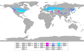
English: Updated world map of the Köppen-Geiger climate classification. Humid continental climates (Dfa, Dwa, Dsa, Dfb, Dwb, Dsb) Magyar: Köppen-Geiger-féle osztályozás. Nedves kontinentális éghajlat (Dfa, Dwa, Dsa, Dfb, Dwb, Dsb) |
| ⴰⵙⴰⴽⵓⴷ | (UTC) |
| ⴰⵙⴰⴳⵎ | |
| ⴰⵎⴳⴰⵢ |
|
| This is a retouched picture, which means that it has been digitally altered from its original version. Modifications: mentioned above +scaled down. The original can be viewed here: Koppen World Map Hi-Res.png:
|
I, the copyright holder of this work, hereby publish it under the following license:
ⵜⵍⵍⴰ ⵜⵓⵔⴰⴳⵜ ⵏ ⵓⴼⴰⵢⵍⵓ ⴰⴷ ⴷⴷⴰⵡ Creative Commons Attribution-Share Alike 3.0 Unported.
- ⵜⴳⵉⴷ ⵉⵍⴻⵍⵍⵉ:
- ⴱⴹⵓ – ⵉ ⵓⵙⵙⵏⵖⵍ, ⴰⴱⵟⵟⵓ ⴷ ⵓⵙⵎⵓⵜⵜⵢ ⵏ ⵜⵡⵓⵔⵉ
- ⵛⵛⴰⵔ – ⵉ ⵓⵙⵎⵙⴰⵙⴰ ⵏ ⵜⵡⵓⵔⵉ
- ⴷⴷⴰⵡ ⵜⴼⴰⴷⵉⵡⵉⵏ ⴰⴷ:
- ⴰⵎⴰⵙ – ⵉⵇⵇⴰⵏ ⴷ ⴰⴷ ⵜⴼⴽⴷ ⵓⵎⵍⴰⵏ ⵖⴼ ⵓⵎⴳⴰⵢ, ⵜⴼⴽⴷ ⴰⵙⵖⵏ ⵖⵔ ⵜⵓⵔⴰⴳⵜ, ⵜⵎⵍⴷ ⵎⴽ ⵜⵜⵓⵙⴽⴰⵔⵏ ⵉⵙⵏⴼⵍⵏ. ⵜⵣⴹⴰⵔⴷ ⴰⴷ ⵜⵙⴽⵔⴷ ⵎⴽ ⴰⴷ ⵙ ⵜⵖⴰⵔⴰⵙⵜ ⵏⵏⴰ ⴷ ⵢⵓⵙⴰⵏ, ⵎⴰⵛⴰ ⵓⵔ ⴷ ⵙ ⴽⵔⴰ ⵏ ⵜⵖⴰⵔⴰⵙⵜ ⵏⵏⴰ ⵉⵙⵙⵓⵎⴰⵔⵏ ⵎⴰⵙ ⴷ ⴰⵎⴳⴰⵢ ⵉⵎⵙⴰⵙⴰ ⴷⵉⴽ ⵏⵉⵖ ⴷ ⵓⵙⵙⵎⵔⵙ ⵏⵏⴽ.
- ⴱⴹⵓⵜ ⵎⴽⵍⵍⵉⵜ – ⵎⴽ ⵜⵙⵏⴼⵍⴷ ⵏⵖ ⵜⵙⵎⵓⵜⵜⵉⴷ ⵏⵖ ⵜⵥⴽⵉⴷ ⵖⴼ ⵜⵡⵓⵔⵉ, ⵉⵇⵇⴰⵏⴽ ⵉⴷ ⴰⴷ ⵜⴱⴹⵓⴷ ⵜⵓⵎⵓⵜⵉⵏ ⵏⴽ ⴷⴷⴰⵡ ⵜⵓⵔⴰⵇⵜ ⴰⵏⵏ ⵏⵉⵜ ⵏⵖ ⴽⵔⴰ ⵏ ⵜⵓⵔⴰⴳⵜ ⴷ ⵢⵓⵙⴰⵏ ⴷ ⵜⴷⵙⵍⴰⵏⵜ.
Original upload log
This image is a derivative work of the following images:
- File:Koppen_World_Map_Hi-Res.png licensed with Cc-by-sa-3.0
- 2011-03-31T22:59:14Z Me ne frego 12047x7383 (1118685 Bytes) More white spots to grey
- 2011-03-31T21:38:00Z Me ne frego 12047x7383 (1119503 Bytes) White spots changed to grey, Caspian Sea to white
- 2011-03-31T17:35:02Z Me ne frego 12047x7383 (1116191 Bytes) {{Information |Description ={{en|1=Updated world map of the Köppen-Geiger climate classification without anti-alising, high resolution.}} |Source =[http://hal.archives-ouvertes.fr/docs/00/29/88/18/PDF/hessd-4-439-
Uploaded with derivativeFX
ⴰⵎⵣⵔⵓⵢ ⵏ ⵓⴼⴰⵢⵍⵓ
ⴽⵍⵉⴽⵉ ⵖⴼ ⵓⵙⴰⴽⵓⴷ/ⴰⴽⵓⴷ ⵃⵎⴰ ⴰⴷ ⵜⵙⴽⵏⴷ ⴰⴼⴰⵢⵍⵓ ⵎⴰⵏⵎⴽ ⴰⴷ ⵢⴰⴷⵍⵍⵉ ⵉⴳⴰ ⴳ ⵡⴰⴽⵓⴷ ⴰⵏⵏ.
| ⴰⵙⴰⴽⵓⴷ/ⴰⴽⵓⴷ | ⵜⴰⵡⵍⴰⴼⵜ ⵎⵥⵥⵉⵢⵏ | ⵉⵎⵏⴰⴷⵏ | ⴰⵏⵙⵙⵎⵔⵙ | ⴰⵖⴼⴰⵡⴰⵍ | |
|---|---|---|---|---|---|
| ⴰⵎⵉⵔⴰⵏ | 10:22, 22 ⵉⴱⵔⵉⵔ 2018 | | 4 231 × 2 592 (1,63 MB) | Trecătorul răcit | Correct limits Dfa & Dfb Pyreneos & Carpathian Mts. |
| 12:46, 4 ⵉⴱⵔⵉⵔ 2011 |  | 4 231 × 2 592 (1,64 MB) | Me ne frego | {{Information |Description={{en|1=Updated world map of the Köppen-Geiger climate classification. '''Humid continental climates (Dfa, Dwa, Dsa, Dfb, Dwb, Dsb)'''}} |Source=*File:Koppen_World_Map_Hi-Res.png |Date=2011-04-04 11:43 (UTC) |Author=*[[:Fi |
ⴰⵙⵎⵔⵙ ⵏ ⵓⴼⴰⵢⵍⵓ
ⵜⴰⵙⵏⴰ ⴰⴷ ⵜⵙⵎⵔⵙ ⴰⴼⴰⵢⵍⵓ ⴰⴷ:
ⴰⵙⵎⵔⵙ ⴰⵖⵣⵓⵔⴰⵏ ⵏ ⵓⴼⴰⵢⵍⵓ
ⵉⵡⵉⴽⵉⵜⵏ ⴰⴷ ⵢⴰⴹⵏⵉⵏ ⴰⵔ ⵙⵙⵎⵔⵙⵏ ⴰⴼⴰⵢⵍⵓ ⴰⴷ:
- ⴰⵙⵎⵔⵙ ⴳ ar.wikipedia.org
- ⴰⵙⵎⵔⵙ ⴳ cs.wikipedia.org
- ⴰⵙⵎⵔⵙ ⴳ en.wikipedia.org
- ⴰⵙⵎⵔⵙ ⴳ es.wikipedia.org
- ⴰⵙⵎⵔⵙ ⴳ fa.wikipedia.org
- ⴰⵙⵎⵔⵙ ⴳ fr.wikipedia.org
- ⴰⵙⵎⵔⵙ ⴳ ha.wikipedia.org
- ⴰⵙⵎⵔⵙ ⴳ he.wikipedia.org
- ⴰⵙⵎⵔⵙ ⴳ hu.wikipedia.org
- ⴰⵙⵎⵔⵙ ⴳ hy.wikipedia.org
- ⴰⵙⵎⵔⵙ ⴳ hyw.wikipedia.org
- ⴰⵙⵎⵔⵙ ⴳ id.wikipedia.org
- ⴰⵙⵎⵔⵙ ⴳ ja.wikipedia.org
- ⴰⵙⵎⵔⵙ ⴳ kab.wikipedia.org
- ⴰⵙⵎⵔⵙ ⴳ lt.wikipedia.org
- ⴰⵙⵎⵔⵙ ⴳ nl.wikipedia.org
- ⴰⵙⵎⵔⵙ ⴳ nn.wikipedia.org
- ⴰⵙⵎⵔⵙ ⴳ no.wikipedia.org
- ⴰⵙⵎⵔⵙ ⴳ oc.wikipedia.org
- ⴰⵙⵎⵔⵙ ⴳ sd.wikipedia.org
- ⴰⵙⵎⵔⵙ ⴳ sh.wikipedia.org
- ⴰⵙⵎⵔⵙ ⴳ simple.wikipedia.org
- ⴰⵙⵎⵔⵙ ⴳ sr.wikipedia.org
- ⴰⵙⵎⵔⵙ ⴳ th.wikipedia.org
- ⴰⵙⵎⵔⵙ ⴳ uk.wikipedia.org
- ⴰⵙⵎⵔⵙ ⴳ ur.wikipedia.org