
ⴰⴼⴰⵢⵍⵓ:Bahrain municipalities numbered.png
ⵓⵔ ⵜⵍⵍⵉ ⵜⵙⴷⴷⵉ ⵉⵎⵇⵇⵓⵔⵏ ⵓⴳⴳⴰⵔ
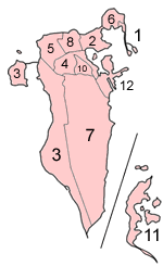
Bahrain_municipalities_numbered.png (150 × 245 ⵉⴷ ⴱⵉⴽⵙⵍ, ⵜⵉⴷⴷⵉ ⵏ ⵓⴼⴰⵢⵍⵓ: 7 KB, ⴰⵏⴰⵡ MIME: image/png)
| ⴰⴳⵍⴰⵎ |
Map of the municipalities of Bahrain (which existed until 2002), numbered in English alphabetical order (using a straight transliteration, rather than translation)
|
| ⴰⵙⴰⴽⵓⴷ | |
| ⴰⵙⴰⴳⵎ | Self-made, traced from public domain UN or CIA maps, with information from the Bahrain government. |
| ⴰⵎⴳⴰⵢ | User:Golbez |
| Other versions | The current map of Bahrain is at Image:Bahrain governorates numbered.png. |
I, the copyright holder of this work, hereby publish it under the following licenses:
This file is licensed under the Creative Commons Attribution-Share Alike 2.5 Generic, 2.0 Generic and 1.0 Generic license.
- ⵜⴳⵉⴷ ⵉⵍⴻⵍⵍⵉ:
- ⴱⴹⵓ – ⵉ ⵓⵙⵙⵏⵖⵍ, ⴰⴱⵟⵟⵓ ⴷ ⵓⵙⵎⵓⵜⵜⵢ ⵏ ⵜⵡⵓⵔⵉ
- ⵛⵛⴰⵔ – ⵉ ⵓⵙⵎⵙⴰⵙⴰ ⵏ ⵜⵡⵓⵔⵉ
- ⴷⴷⴰⵡ ⵜⴼⴰⴷⵉⵡⵉⵏ ⴰⴷ:
- ⴰⵎⴰⵙ – ⵉⵇⵇⴰⵏ ⴷ ⴰⴷ ⵜⴼⴽⴷ ⵓⵎⵍⴰⵏ ⵖⴼ ⵓⵎⴳⴰⵢ, ⵜⴼⴽⴷ ⴰⵙⵖⵏ ⵖⵔ ⵜⵓⵔⴰⴳⵜ, ⵜⵎⵍⴷ ⵉⵖ ⵉⵜⵜⵡⴰⵙⵏⴼⵍ. ⵜⵣⴹⴰⵔⴷ ⴰⴷ ⵜⵙⴽⵔⴷ ⵎⴽ ⴰⴷ ⵙ ⵜⵖⴰⵔⴰⵙⵜ ⵏⵏⴰ ⴷ ⵢⵓⵙⴰⵏ, ⵎⴰⵛ ⵓⵔ ⴷ ⴽⵔⴰ ⵏ ⵜⵖⴰⵔⴰⵙⵜ ⵉⵎⵎⴰⵍⵏ ⵎⴰ ⵙ ⴷ ⴰⵎⴳⴰⵢ ⴰⵔ ⴽ ⵉⵏⵏⴰⵍ ⵏⵖ ⴷ ⴰⵙⵎⵔⵙ ⵏⴽ.
- ⴱⴹⵓⵜ ⵎⴽⵍⵍⵉⵜ – ⵎⴽ ⵜⵙⵏⴼⵍⴷ ⵏⵖ ⵜⵙⵎⵓⵜⵜⵉⴷ ⵏⵖ ⵜⵥⴽⵉⴷ ⵖⴼ ⵜⵡⵓⵔⵉ, ⵉⵇⵇⴰⵏⴽ ⵉⴷ ⴰⴷ ⵜⴱⴹⵓⴷ ⵜⵓⵎⵓⵜⵉⵏ ⵏⴽ ⴷⴷⴰⵡ ⵜⵓⵔⴰⵇⵜ ⴰⵏⵏ ⵏⵉⵜ ⵏⵖ ⴽⵔⴰ ⵏ ⵜⵓⵔⴰⴳⵜ ⴷ ⵢⵓⵙⴰⵏ ⴷ ⵜⴷⵙⵍⴰⵏⵜ.

|
ⵖⵓⵔⴽ ⵜⵓⵔⴰⴳⵜ ⵏ ⴰⴷ ⵜⵙⵙⵏⵖⵍⴷ, ⴰⴷ ⵜⴱⴹⵓⴷ ⴷ ⴰⴷ ⵜⵙⵏⴼⵍⴷ ⵜⴰⵏⵜⴰⵎⵜ ⴰⴷ ⴷⴷⵓ ⵜⴼⴰⴷⵉⵡⵉⵏ ⵏ ⵜⵓⵔⴰⴳⵜ ⵊⵉⵏⵓ ⵉ ⵜⵏⵜⴰⵎⵉⵏ ⵜⵉⵍⴻⵍⵍⵉⵢⵉⵏ ⵜⵓⵏⵖⵉⵍⵜ 1.2 ⵏⵖ ⵜⵓⵏⵖⵉⵍⵜ ⵜⴰⵎⴰⵢⵏⵓⵜ ⴰⴽⴽ ⵏⵏⴰ ⵜⵥⵔⴳ ⵜⴰⵎⵔⵙⵍⵜ ⵏ ⵉⵙⵓⴼⵜⵡⵓⵔⵏ ⵉⵍⴻⵍⵍⵉⵢⵏ, ⵎⵉⵏ ⵜⵉⵣⵓⵏⵉⵡⵉⵏ ⴰⵔⵎⵙⴽⵉⵍⵏ, ⵎⵉⵏ ⴰⴹⵔⵉⵙ ⵏ ⵜⴰⵙⵏⴰ ⵜⴰⵎⵣⵡⴰⵔⵓⵜ ⵏ ⵜⴷⵓⵍⵉ ⴷ ⵎⵉⵏ ⴰⴹⵔⵉⵙ ⵏ ⵜⴰⵙⵏⴰ ⵜⴰⵎⴳⴳⴰⵔⵓⵜ ⵏ ⵜⴷⵓⵍⵉ.ⵢⴰⵜ ⵜⵓⵏⵖⵉⵍⵜ ⵏ ⵜⵓⵔⴰⴳⵜ ⵜⴽⵛⵎ ⴳ ⵜⵣⵓⵏⵉ ⵉⵍⴰⵏ ⴰⵣⵡⵍ GNU Free Documentation License. |
| ⴰⴼⴰⵢⵍⵓ ⴰⴷ ⵉⵍⵍⴰ ⴷⴷⵓ ⵜⴼⴰⴷⵉⵡⵉⵏ ⵏⵜⵓⵔⴰⴳⵜ Creative Commons Attribution - Partage dans les Mêmes Conditions 3.0 (non transposée). | ||
| ||
| This licensing tag was added to this file as part of the GFDL licensing update. |
ⵜⵣⵎⵔⴷ ⴰⴷ ⵜⵙⵜⵉⴷ ⵜⵓⵔⴰⴳⵜ ⵏⵏⴰ ⵜⵔⵉⴷ.
ⴰⵎⵣⵔⵓⵢ ⵏ ⵓⴼⴰⵢⵍⵓ
ⴽⵍⵉⴽⵉ ⵖⴼ ⵓⵙⴰⴽⵓⴷ/ⴰⴽⵓⴷ ⵃⵎⴰ ⴰⴷ ⵜⵙⴽⵏⴷ ⴰⴼⴰⵢⵍⵓ ⵎⴰⵏⵎⴽ ⴰⴷ ⵢⴰⴷⵍⵍⵉ ⵉⴳⴰ ⴳ ⵡⴰⴽⵓⴷ ⴰⵏⵏ.
| ⴰⵙⴰⴽⵓⴷ/ⴰⴽⵓⴷ | ⵜⴰⵡⵍⴰⴼⵜ ⵎⵥⵥⵉⵢⵏ | ⵉⵎⵏⴰⴷⵏ | ⴰⵏⵙⵙⵎⵔⵙ | ⴰⵖⴼⴰⵡⴰⵍ | |
|---|---|---|---|---|---|
| ⴰⵎⵉⵔⴰⵏ | 06:51, 18 ⴷⵓⵊⴰⵏⴱⵉⵔ 2004 | | 150 × 245 (7 KB) | Golbez | Map of Bahrain showing municipalities. Made by User:Golbez. {{GFDL}} |
ⴰⵙⵎⵔⵙ ⵏ ⵓⴼⴰⵢⵍⵓ
ⵜⴰⵙⵏⴰ ⴰⴷ ⵜⵙⵎⵔⵙ ⴰⴼⴰⵢⵍⵓ ⴰⴷ:
ⴰⵙⵎⵔⵙ ⴰⵖⵣⵓⵔⴰⵏ ⵏ ⵓⴼⴰⵢⵍⵓ
ⵉⵡⵉⴽⵉⵜⵏ ⴰⴷ ⵢⴰⴹⵏⵉⵏ ⴰⵔ ⵙⵙⵎⵔⵙⵏ ⴰⴼⴰⵢⵍⵓ ⴰⴷ:
- ⴰⵙⵎⵔⵙ ⴳ ar.wikipedia.org
- البحرين
- المحرق (مدينة)
- محافظة العاصمة (البحرين)
- محافظة المحرق
- الشمالية (محافظة)
- جنوبية (محافظة)
- قالب:محافظات البحرين
- المحافظة الوسطى (البحرين)
- محافظات البحرين
- مدينة عيسى
- الحد (مدينة)
- جزر حوار
- ويكيبيديا:مشروع ويكي البحرين
- بوابة:البحرين
- بوابة:البحرين/قوالب
- بريد البحرين
- البلديات السابقة في البحرين
- المنطقة الوسطى (البحرين)
- الرفاع والمنطقة الجنوبية (البحرين)
- المنطقة الغربية (البحرين)
- ⴰⵙⵎⵔⵙ ⴳ el.wikipedia.org
- ⴰⵙⵎⵔⵙ ⴳ en.wikipedia.org
- Manama
- Central Governorate, Bahrain
- Capital Governorate, Bahrain
- Muharraq Governorate
- Northern Governorate
- Southern Governorate
- Al Hidd
- Western Region, Bahrain
- Rifa and Southern Region, Bahrain
- Isa Town
- Central Region, Bahrain
- Northern Region, Bahrain
- Muharraq
- Template:Governorates of Bahrain
- Former regions of Bahrain
- Bahrain
- Governorates of Bahrain
- Portal:Bahrain
- Portal:Bahrain/Topics
- ⴰⵙⵎⵔⵙ ⴳ eo.wikipedia.org
- ⴰⵙⵎⵔⵙ ⴳ eu.wikipedia.org
- ⴰⵙⵎⵔⵙ ⴳ fr.wikipedia.org
- ⴰⵙⵎⵔⵙ ⴳ gl.wikipedia.org
- ⴰⵙⵎⵔⵙ ⴳ hy.wikipedia.org
- ⴰⵙⵎⵔⵙ ⴳ id.wikipedia.org
- ⴰⵙⵎⵔⵙ ⴳ incubator.wikimedia.org
- ⴰⵙⵎⵔⵙ ⴳ is.wikipedia.org
- ⴰⵙⵎⵔⵙ ⴳ it.wikipedia.org
ⵙⴽⵏ ⵓⴳⴳⴰⵔ ⵖⴼ ⵓⵙⵙⵎⵔⵙ ⴰⵎⴰⵜⴰⵢ ⵏ ⵓⴼⴰⵢⵍⵓ ⴰⴷ.